“The glaciers contain enough ice to raise global sea levels by 1.2 meters.”
There’s enough water frozen in the ice sheet that feeds these icy giants to raise global sea levels by 4 feet (1.2 meters) if they were to melt. That’s troubling because the glaciers are melting.
Moreover, a new study finds that their decline appears to be irreversible.Rignot and colleagues have used 19 years ofsatelliteradardata to map the fast-melting glaciers.In their paper …theyconclude that ‘this sector of West Antarctica is undergoing a marine ice sheet instability thatwillsignificantly contribute to sea level rise’ in the centuries ahead.A key concept in theRignot study is the ‘grounding line’ the dividing line between land and water underneath a glacier.Because virtually all melting occurs where the glaciers’ undersides touch the ocean, pinpointing the grounding line is crucial for estimating melt rates.
In all the glaciers they studied, grounding lines were rapidly retreating away from the sea.‘In this sector, we are seeing retreat rates that we don’t see anywhere else on Earth,’Rignot says.Smith Glacier’s line moved the fastest, retreating 22 miles upstream. The other lines retreated from 6 to 19 miles. As the glaciers melt and lose weight, they float off the land where they used to sit.Water gets underneath the glacier and pushes the grounding line inland. This, in turn, reduces friction between the glacier and its bed. The glacier speeds up, stretches out and thins, which drives the grounding line to retreat farther inland. This is a positive feedback loop that leads to out of control melting.‘At current melt rates,’ concludes Rignot, ‘these glaciers will be ‘history’ within a few hundred years.’
Here’s an image detailing the difference between the 1996 and 2011 grounding line:
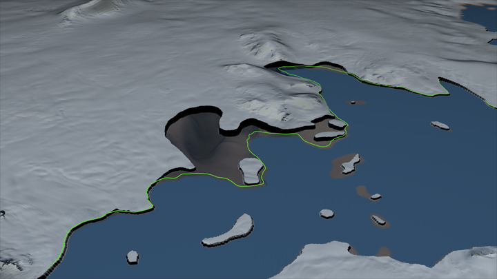
A print resolution image showing the Smith Glacier and the adjacent ice shelves. Here the region covered by the ice shelves is colored blue. The white area shows where the glacier is over bedrock. The boundary traced by the green line shows the location of the grounding line in 1996. The edge of the white region indicates the location of the grounding line in 2011, which has retreated inland 35 km from the 1996 location. The area between the 1996 and 2011 grounding lines is shown as semi-transparent in order to view the depth of the valley beneath the glacier. source: NASA’s Scientific Visualization Studio
And this is an applet to see the difference yourself:
Source & Credit: NASA’s Scientific Visualization Studio – “West Antarctic Collapse”
