How Groundwater Extraction & Replenishing Causes Surface Deformation & Subsidence

Standard

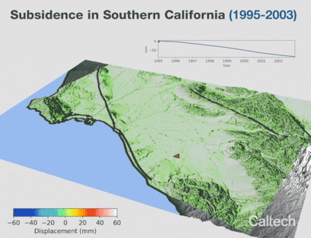
Researchers at Caltech made the animations below which show the seasonal deformation and subsidence of Earth’s surface, respectively,  as a result of groundwater extraction and refilling. This occurs when soil and earth layers are compacted and undergo subsidence due to the decrease of upward hydrostatic pressure balancing the weight of the layers.

Surface deformation and subsidence of Earth’s surface is measured using Interferometric Synthetic Aperture Radar (ISAR). ISAR is also used for natural hazard assessment. This includes applications to regions of volcanic, tectonic (e.g. faults and mountains), and construction activities.


source: Caltech

Advertisement

Snow in the Desert

Image

source: NASA Earth Observatory

via [NASA Earth Observatory]

Global SRTM Map

Image
global_srtm_bathymetry_map

The following is an 20x downsampled global Shuttle Radar Topography Mission (SRTM)  map made with Python and Basemap.

Full resolution can be found on wikimedia.

One can notice the depth of the ocean floor, on a global scale, ranges between -2000 and -6000 meters. In some regions though like the Pacific exceed this range and reach 11 kilometers below the sea surface. One such region is the deepest point on Earth, the Mariana trench as shown below followed by a map for a perspective of its location.

368px-marianatrenchmap

Location of the Mariana trench. Wikimedia commons.

Credits: The SRTM dataset used was provided by IFREMER.

Radio interference around & Salinity in the Mediterranean

Image

When ESA’s SMOS satellite was placed in orbit in 2009, it transpired that its signal was being interrupted by numerous illegal transmitters around the world. However, by working with national frequency protection authorities, 75% of these transmitters have now been shut down. Nevertheless, this is a laborious process and some regions, such as the Libyan coast and the eastern Mediterranean Sea, remain contaminated where mitigation strategies have not yet been successful. Source: ESA

Thanks to new processing techniques, information from ESA’s SMOS mission can be used to map salinity in the surface waters of the Mediterranean Sea. For example, daily maps can be created using DINEOF, which reduces noise and other sources of contamination. The image, which captures salinity on 3 March 2013, shows the fresher water from the Atlantic Ocean flowing through the Strait of Gibraltar into the Mediterranean Sea. Source: ESA